Year 1 Days 50 and 51 Dust Is Flying

These last two days have been so hectic that I have not had a chance to write the blog.  I had anticipated this and was planning on mostly posting pictures of my exploration of Tombstone instead of writing a lot of text as a means of dealing with being so busy.  However, the degree of busyness was more than either Mary Margaret or I expected.  Thus, the absence of the blog.  Sigh!

Yesterday, we packed up LeuC and drove the short distance from Kartchner Caverns State Park to Tucson (about 50 miles).  We had an 8 AM appointment with the La Mesa RV folks for today that we needed to keep.  When we left Tucson last month, they had ordered some parts which have now arrived and are ready to be installed.  Also, we had a short list of To Do’s for them as a result of our “shake down” trip to Denver and back.

We had decided that we would spend our first night night parked in the Casa Del Sol Casino parking lot and then, early this morning, drive LeuC to La Mesa RV and drop her off for the day.  While LeuC was being worked on, we would then run a few errands.  Shuffled with all this would be getting together with our daughter, Christina, and her family for dinners on both night.

As it turned out, this is exactly what we did but instead of leisurely running errands today, it ended up being a 7AM to 4:30 PM ordeal.  Whew!

Spending the night at the casino worked out very well since it was free, and Mary Margaret ended up winning a few bucks.  Since we were not plugged in to power, we ran the generator a couple of hours last night just to be able to run the A/C to cool LeuC down before bedtime.

Tonight, we are spending the night at the Desert Diamond Casino since it is a bit closer to both La Mesa RV and Christina’s house.  It also seems to be nice and quiet.  At both casinos we shared the outer parking lot with about a dozen other RV rigs, with lots of space between us.

The casino folks are very friendly and have no problem with our using their parking lot, especially since we were spending only a night at each one.  In fact, at the Desert Diamond Casino, a gal in a golf cart came over and gave me her cell number to call whenever we wanted a lift to the casino.  Mary Margaret will do that tomorrow morning while I am at the Fiat dealership having our new spare tire installed.  You may recall that our little Fiat did not come with a spare tire when we bought it.  I have never liked not having a spare tire, especially since we have been driving it around in some pretty desolate places.  Buying the spare tire and making an appointment to have it installed underneath our little Fiat was one of just a dozen stops we made today during our “leisurely” errand run.

Once the spare tire is installed, we will be driving up to Mesa, Arizona to stay at the Ursery Mountain Regional Park for a few days as we continue our trek to Southern California.  Once in Mesa we hope to take a few days off and rest up.  Yeah, right… we have a good track record of doing that!  LOL

Here are some of the Tombstone photos I have threaten you about.  These are of its old Boothill Graveyard. Initially, I was overwhelmed by the number of graves that were marked as containing someone who was killed in a gunfight, brawl or murdered.  However, some simple research into this has revealed that most of the claims are fictitious, being an effort to attract tourists.  It seems to be working as Boothill is one of Tombstone’s most popular stopping places.  Here is what the TrueWest Magazine wrote:

Billy Clanton and Tom and Frank McLaury are buried in the right spot, says Ben Traywick, Tombstone historian and author of Boot Hill. Other bodies in the correct location are M.R. Peel, murdered in Charleston (10 miles south of Tombstone); the five men hanged in 1884 for the Bisbee Massacre—Arizona’s largest mass hanging; some ladies from the red light district; and a few Chinese citizens. Everyone else is just speculation.”.

OLYMPUS DIGITAL CAMERA


Year 1 Day 50 Tombstone

This morning I hopped in our little Fiat and drove over to explore the old Wild West town of Tombstone.  Mary Margaret opted out, wanting to relax a bit more while doing another load of laundry.  Undaunted, I pushed on by myself.

I ended up spending all day in Tombstone as there were lots of old buildings, some of them originals dating back to the 1880s, which have been turned into museums.  The town had been gutted a couple of times during its heydays by fire.  Thus, most of the buildings are reconstructions, trying to show the modern-day tourists what it looked like way back when.

THEN:

OLYMPUS DIGITAL CAMERA

NOW:

OLYMPUS DIGITAL CAMERA

Back in the early 1880s there were fancy French and Italian restaurants, along with several Chinese and Mexican restaurants, chop houses and upscale “Continental” establishments.  The town boasted a bowling alley, four churches (Catholic, Episcopal, Presbyterian, and Methodist), an ice house, a school, the Schieffelin Hall opera house, two banks, three newspapers, and an ice cream parlor.  It also had over 110 saloons, 14 gambling halls and too many brothels to count.  They and the town were all situated among and on top of a number of small, hardscrabble mines. OLYMPUS DIGITAL CAMERAThe Arizona Telephone Company began installing poles and lines for the city’s first telephone service in 1881.

While there, I learned that the town heydays lasted only until around 1886 when a fire destroyed the main pumping system that kept the mines open, plus the price of silver plummeted to less than 90 cents an ounce.  With the mines closed, there was no wealth to support businesses resulting in the population leaving, seeking opportunities elsewhere.  Almost overnight the booming mining town became close to a ghost town.  It barely survived, mostly because it remained the Cochise Country seat until 1929, when it was voted to move the official offices to Bisbee.

I took lots of pictures while there and will post a few of them today and many more over the next few days.  There are just too many to post in one blog.  Plus, in a previous blog, I had promised to finish the history of the days leading up to the famous “Gunfight at the OK Corral”.

If you will recall, there was a history of bad blood between the Clantons and the members of the outlaw gang known as The Cowboys (who made the Clanton ranch their base) and the Earps.  With this in mind, here is the chronology of events:

October 13, 1881: Deputy U.S. Marshal Virgil Earp and his brother Wyatt arrested Frank Stilwell and Pete Spence for a stagecoach robbery. Stilwell and Spence had just been acquitted for lack of evidence on similar charges filed at the local level.  Since Stilwell and Spence were friends with members of The Cowboy gang, gang members saw the new arrest as evidence that Stilwell and Spence were being unfairly harassed and targeted by the Earps for any stage robbery. They let the Earps know they could expect retaliation.

October 17, 1881: Morgan Earp was named as a special police officer in Tombstone by his brother, police chief Virgil Earp.

October 21, 1881: Morgan Earp hurried to Tucson to get Doc Holliday after trouble was brewing in Tombstone. He found Doc with his girlfriend, “Big Nose” Kate, at the San Augustin Feast and Fair in Levin Park.

October 22, 1881: Morgan Earp accompanied Doc Holliday on a freight train stock car as they returned to Tombstone from Tucson.

October 24, 1881: An editorial in the Tombstone Nugget predicted violence just two days before the West’s most celebrated gunfight: “The arming of oneself in a peaceful community, as every well-organized community is supposed to be, and walking about like a moving arsenal, is highly ridiculous and, as events demonstrate, exceedingly dangerous.”

October 25, 1881: Members of The Cowboys gang, Ike and brother Billy Clanton with brothers Frank and Tom McLaury, arrived in Tombstone.  They planned to enjoy some time in the town and involved themselves in drinking and gambling through the night.  At some point during the night, Ike got into an altercation with Doc Holliday at the Alhambra Saloon.

October 26, 1881: A series of events led to a date with destiny. Throughout the morning, residents of Tombstone warned the Earps brothers and Doc Holliday that Ike Clanton had been making threats for hours. They were told he intended to kill them and was brandishing a rifle after drinking all night.  Chief of Police Virgil Earp found Ike on the street and before anything could happen, hit him over the head with his pistol.  He and Special Officer Morgan Earp drug Ike off to court where he was fined $27.50.  As Wyatt Earp left the courtroom, Tom McLaury approached him where another verbal altercation took place. It resulted much the same way:  Wyatt drew his pistol and hit Tom over the head with it.

Later in the afternoon, the Clantons and McLaury were seen in Spangenberg’s gun shop loading their belts with ammunition.  In an apparent attempt to disarm the cowboys, Virgil gathered together his brothers Wyatt and Morgan along with friend Doc Holliday for a march to the O.K. Corral.  They discovered the cowboys were armed and a gunfight broke out.  When the smoke cleared, Billy Clanton, 19, and both Frank, 33, and Tom McLaury, 28, were dead.  In the middle of the fight Ike Clanton had run away. Morgan Earp had a serious wound through his shoulder.  Virgil Earp was shot in the leg. “Doc” Holliday had been grazed on his hip by a bullet.  Wyatt was unscathed.  The gunfight lasted less than 30 seconds.

OLYMPUS DIGITAL CAMERA

Shootout OK Corral

Who actually started the shooting has been a subject of much speculation.

Year 1 Day 49 Exploring Kartchner Caverns

Late this morning we drove the short distance to the Kartchner Caverns’ Visitor Center. We had reservations to tour the caverns. There are two tours, each 1 1/2 hours in length and involving about a half-mile of walking. The Rotunda/Throne Room tour is conducted year-round, while the Big Room is toured only from October through mid-April — because a community of bats uses it as a maternity nursery in the summer, and park officials don’t want to disturb them by trooping tourists through. We had opted for the Big Room tour.

At the Visitor’s Center we enjoyed the various cave exhibits and a movie how in 1974 two young spelunkers squeezed into a sinkhole in a godforsaken area near the Whetstone Mountains, southeast of Tucson, Arizona and discovered one of the most marvelous cave system’s in the US.

The cave and its series of underground chambers that Randy Tufts and Gary Tenen discovered that day is now known as the Kartchner Caverns, located in the foothills south of Benson, Arizona. The cavers kept their find a secret for 14 years to ensure the caverns remained as pristine as when they discovered them. It took that long for them to find someone who would protect the caverns, so they would remain pristine yet let the public enjoy them. It was the Arizona State Parks who stepped up and with state funding, developed the protective measures that are now in place. Unlike other caverns around the US, the number of visitors is limited, they are misted when they go in so as to maintain the remarkably humid environment, and visitors are not allowed to touch anything but the handrails to avoid having the oils on their skin damage formations.

To enter Kartchner’s interior you go through 6 large, stainless steel bank vault type air-lock doors in the entry tunnel to prevent the outside air drying out the inside of the caverns and killing off formation development and the little cave dwellers. Because it took humans so long to discover these caves, management of them have benefited considerably from hindsight. Carlsbad Caverns in New Mexico suffered after an elevator was installed in 1931; it proved to be a vent for warm, desert air that began to dry out the cave’s natural features.

As we descended deep into the mountain, we saw various cave formations including: popcorn coralloids, fried egg stalagmites, turnip shields, carrots, bacon drapery, butterscotch drapery, moon milk, and soda straws. One soda straw was over 21 foot long!

It can be a disorienting experience to descend below the earth, even under these carefully controlled conditions. The temperature of the caverns averages 68 degrees year-round, yet the humidity level is that of Florida in summer — 98 percent.

Mary Margaret and I have done a fair amount of cave explorations. This goes way back to the 1970s when, still without children, we donned mining helmets and with only the light given off by our carbide flame helmet lanterns, crawled and slimed our way through a cavern in West Virginia. Since then, we have toured Grand Canyon Caverns near Kingman, AZ; California Caverns in the foothills of the Sierras; lava tubes at the Lava Beds National Monument near Lassen, CA; Sea Lion Caves along the Oregon coast, Abbey Caves near Whangarei, New Zealand; huge sea caves on the Caribbean island of Barbados; sea caves in Tonga; and a neat sea cave in our old backyard within the Dana Point headland.

With all of these experiences, this was the very first time we actually felt a little dizzy as we wound our way down into the caverns. I cannot explain why this was so, but we were glad there were handrails to hold onto to keep from stumbling or falling as we viewed the amazing subterranean structures.

We were restricted from taking photographs due to the concern the flashes would impact the caves somehow. I still don’t understand this, but it was the rule. Thus, I have gone to the Internet and gleaned a number of photos of what we saw in person to share with you.


Year 1 Day 48 Just A “Little” Historical Background

We spent today doing our “slug” imitation.  We decided that what we need to do is to increase our imitation just so we can rest up after these last hectic seven weeks of travel and exploration.  Unfortunately, this is not going to happen very often as we have much more to do and places to see before we will have time to just “stop and smell the roses”.  We are thinking that this might happen when we return to Tucson in the latter half of November to spend Thanksgiving with our daughter, Christina, and her family.  At that time, we will have two weeks before we return to the San Francisco area to spend the Christmas holidays with our other two children, Heather and David Paul, and their families.

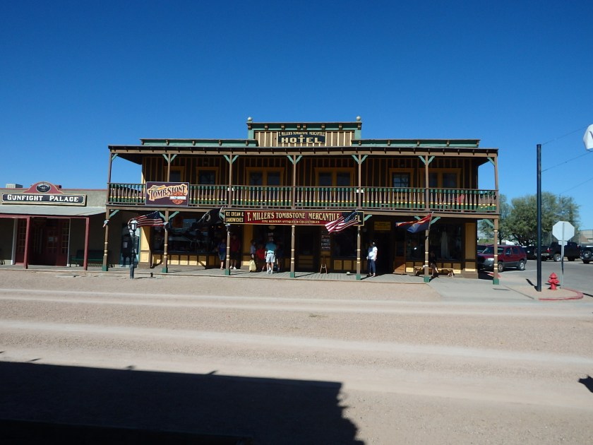
Since it was a slug day, I decided to do some research on Tombstone and its infamous “Gunfight at the OK Corral”.  We hope to drive over to Tombstone the day after tomorrow since it is so close.

Here is what I discovered while doing my research:

In 1877, Ed Schieffelin was a prospector but at the time was working as an Indian scout for the U.S. Army who were hunting the Chiricahua Apaches. He was garrisoned at Camp Huachuca, located about 15 miles north of the Mexican border, which has since become Fort Huachuca and is still an active Army base.

While at Camp Huachuca, Schieffelin would leave the camp to look for potential ore deposits within the wilderness despite the fact that fellow soldiers at his camp warned him not to. The soldiers told him that he better take his coffin with him as he would find his tombstone there and nothing else.

While he did not find his tombstone, he did find silver.  Having a sense of humor, he named  his very first mine The Tombstone.

Apparently, Schieffelin was quite a character, as shown by this 1876 description given by David P. Lansing of Phoenix, Arizona:

[He is] “about the strangest specimen of human flesh I ever saw. He was 6 feet 2 inches tall and had black hair that hung several inches below his shoulder and a beard that had not been trimmed or combed for so long a time that it was a mass of unkempt knots and mats. He wore clothing pieced and patched from deerskins, corduroy and flannel, and his hat was originally a slouch hat that had been pieced with rabbit skin until very little of the original felt remained.

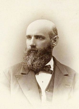
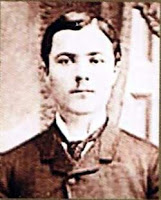
Here is Ed after he discovered silver and cleaned up a bit.


Word quickly spread about his silver strike. It wasn’t long before homesteaders, cowboys, speculators, prospectors, lawyers, business people and gunmen headed to the area.  Known originally as Goose Glats, the town site was situated near the mines and in 1879 and was renamed Tombstone after the first claim of silver mining by Schieffelin.

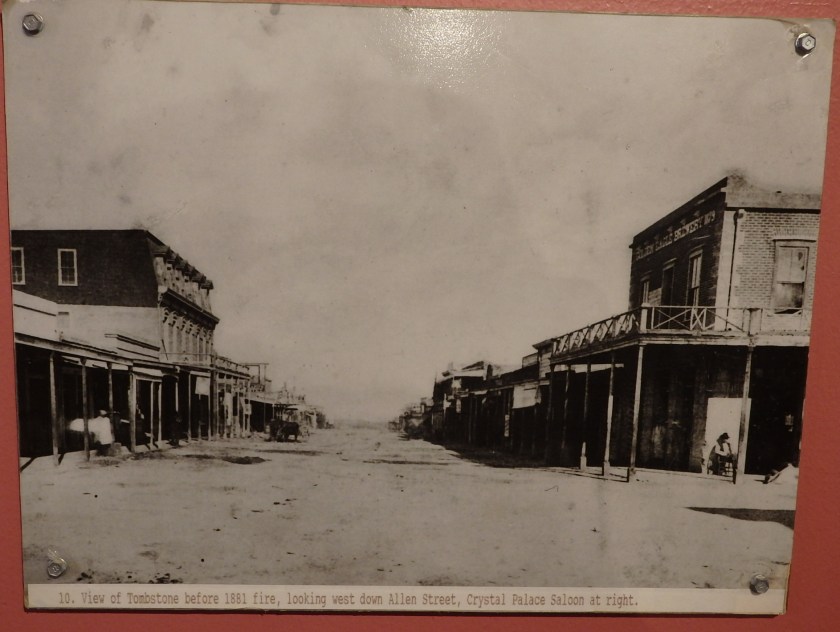
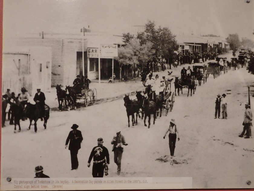
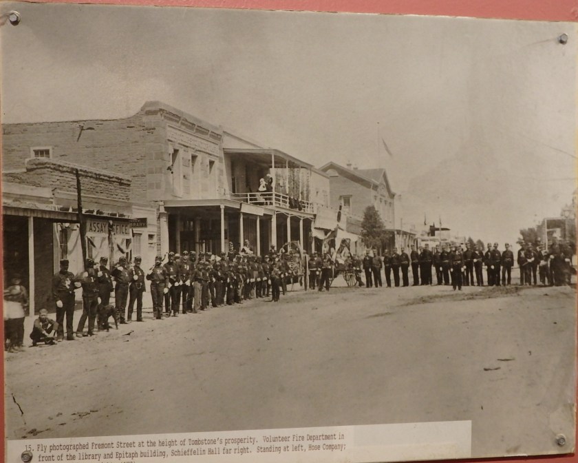
Tombstone quickly became a rough and tumble proto-typical western mining town and grew as the local mines produced $40 to $85 million in silver bullion, the largest productive silver district in Arizona. Its population grew from 100 to around 14,000 in less than seven years.

Tombstone circa 1881

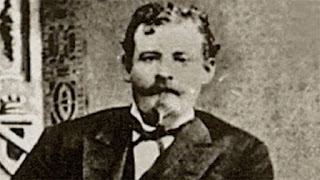
During these early heydays, Tombstone attracted a number of famous and infamous people, including the Earp brothers: Vigil, Wyatt, and Morgan and Doc Holliday.

 In December 1879 Wyatt Earp and his two brothers with the brother’s respective wives, arrived in the new silver mining town of Tombstone.  Virgil Earp had been appointed Deputy U.S. Marshal for eastern Pima County in Prescott and had been directed to relocate to Tombstone to concentrate on suppressing a group of rustlers and stage and bank robbers known as the “Cochise County Cowboys” or just “The Cowboys”.

Wyatt had hoped to establish a stage line here, but upon discovering that there were already two in town, he acquired the gambling concession at the Oriental Saloon. It was here that Wyatt met his third wife Josie, who remained with him until his death in 1929.

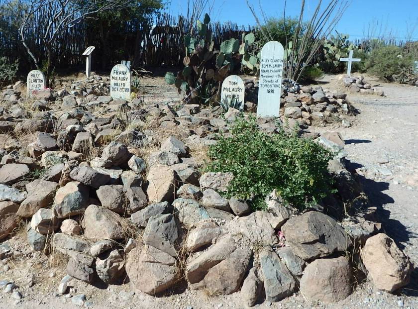
The notoriety and power of The Cowboys had spread from coast to coast. Well-known members of the group included Phin, Billy, and Ike of the Clanton family; Tom and Frank McLaury; William “Curly Bill” Brocius; “Buckskin Frank” Leslie; Johnny Ringo; and Pony Diehl. They used the Clanton’s ranch as their base.

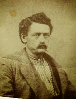
Curly Bill Brocius, Ike and Billy Clanton

A few days after the Earps arrival in Tombstone in December 1879, one of Wyatt’s prized horses was stolen. He heard several times that the Clantons had his horse. Almost a year later he got a tip that it had been seen at the Clanton’s ranch near Charleston Arizona. Earp rode to Charleston with his friend, Doc Holliday, and saw the horse being ridden down a street and then placed in a corral. They stabled their horses at another corral and Wyatt telegraphed his brothers in Tombstone to send up ownership papers for the horse to Charleston. Wyatt testified in a later court hearing,

While I was waiting for the papers, Billy Clanton found out that I was in town and went and tried to take the horse out of the corral. I told him that he could not take him out, that it was my horse. After the papers came, he gave the horse up without the papers being served, and asked me if I had any more horses to lose.

During 1880 and 1881 there were numerous run-ins between the Earps, the Clayton family and other members of The Cowboys gang.  In October 1880, Wyatt Earp, now a U.S. Deputy Marshall, arrested William ‘Curly Bill’ Brocius, for the murder of Tombstone marshal Fred White.  When Brocius was found not guilty, tensions intensified.

Wyatt believed The Cowboys were involved in a bungled stagecoach robbery in March 1881. Two men on the stage were killed.  Ike Clanton publicly blamed Doc Holliday instead.  In July 1881, Curly Bill Brocius and gunfighter Johnny Ringo headed for New Mexico to kill two brothers, William and Isaac Haslett.  A few weeks earlier Cowboy members Bill Leonard and Harry Head died during an attempted robbery at the Haslett brothers’ general store.

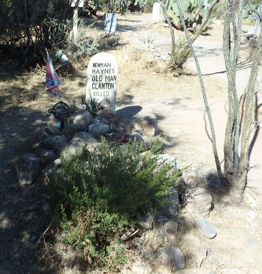
Later that month, Curly Bill led an ambush against a Mexican trail herd at San Luis Pass. They killed six vaqueros and tortured eight. This ultimately led to the death of the patriarch of the Clanton family, Newton “Old Man” Clanton.

In 1879, Old Man Clanton had established a ranch near Goose Glats which was soon to be re-named Tombstone and did very well selling stolen beef to the miners and others that flocked into the area.  He was killed on August 12, 1881, when he and six other men began a journey herding stolen Mexican cattle through Guadalupe Canyon near the Mexican border.  Around dawn, after spending the first day and night on the trail, they were ambushed by Mexicans dispatched by Commandant Felipe Neri in what was later dubbed the Guadalupe Canyon Massacre. Five men were killed in the ambush.  Old Man Clanton, who was cooking breakfast when he was shot, fell dead into the cook fire.

On September 16, 1881, a little more than a month before the Gunfight at the O.K. Corral, the local paper, The Tombstone Epitaph, wrote about the “Cow-boy Nuisance” in Arizona:

“It has come to pass in this county that life and personal property are unsafe; even in the town of Tombstone it seems as if one of the leading industries is to be destroyed. There is not a teamster to-day who is not in fear and dread of the cow-boys, or so-styled “rustlers” depriving him of his hard earnings… How must such men feel to be robbed by a hand of thieves and cutthroats, who take pride in announcing to the public that they are “rustlers!” Where is the teamsters protection? Can you find any officers who will follow, arrest and recover your property? If you can, I would like to see him… These chaps seem to have no difficulty in evading the law, while others, not inclined to work, daily join the band and they are increasing fast in numbers. Our town is filled with spies watching every move of the officers and imparting their information to their comrades… Men who come to examine different mines outside of town, when they learn how the cow-boys stand fellows up, do not wish to run such risks; they quietly take the road they came and get into civilization as soon as possible.”

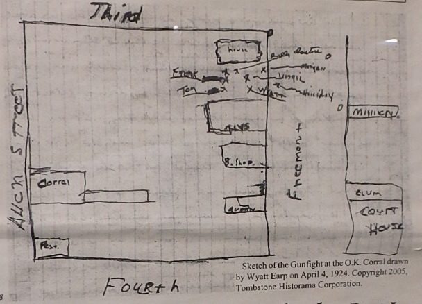
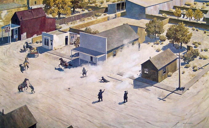
Now, armed with all of this background, I will document the last few days that led up to “The Gunfight at the OK Corral” when I write the blog of our trip to Tombstone in two days.

Year 1 Day 47 Antique Car Rally

Before we headed out this morning for our next campsite at Kartchner Caverns State Park, we stopped by the parking lot next to the park ranger’s office at Pancho Villa State Park.  Today was the day of the 12th annual Pancho Villa Antique Car Rally.  We had never been to such an affair and it was pretty neat.

We actually arrived before it was official open, since we had miles to make this morning.  We had a chance to inspect may of the cars and trucks that had arrived, and their owners were in the process of setting up, polished their pride and joys to a high gloss.

While we were impressed with each antique, we were really impressed with each owner and his or her family.  They all had a passion for their vehicle and enjoyed telling us all about it.  We learned a lot and many of the vehicles brought back fond memories of lost youth.  My dad and mom once had a 1966 Mustang convertible that I spent many hours driving up and down the coastline between Monterey and San Francisco during my college summers.  Oh!  What a hoot that was!  Good times!

Here are a few of the cars we saw:

OLYMPUS DIGITAL CAMERA

While dwarfed by this classic, here is our favorite car!

OLYMPUS DIGITAL CAMERA

We faced a 3 hour drive to return to Arizona and then south into the foothills near the town of Benson.  We arrived at the Kartchner Caverns State Park and discovered a lovely park with wide spaces between each campsite and lots of desert trees adding to the ambiance.   There are sites with 50 amp electricity, water, picnic tables and a fire ring for RVs such as ours, other sites just for tent camping and even some small adobe cabins (casitas) for those who want to rough it with the comforts of home.

OLYMPUS DIGITAL CAMERA

We will be here for 4 nights which will give us a day to rest (tomorrow), a day to explore the caverns, and a day to drive over to nearby Tombstone and explore there.  After that, it will be on to Tucson for a couple of days before we continue west toward Southern California.

Year 1 Day 46 Dipping Our Toes Into Mexico

Year 1 Day 46 Dipping Our Toes Into Mexico

In 2015, we flew down to central Mexico and spent a week or so in Chapala, near Guadalajara to visit with our dear cruising friends, Portia and Steve, formerly of S/V Dream Caper.  They gave us a wonderful tour of that area and we ate like kings and queens, loving the wonderful flavors that only the Mexicans can create.  It was with that memory, of that visit, and the wonderful food we enjoyed so much that we decided to cross the border and visit Palomas, Mexico.

We did this even though some folks who live in New Mexico that we met at one of the rest stops yesterday, warned us that the village has been the spot of recent violence between drug cartel gangs.  Before we made our decision to go, I did some research into the crimes affiliated with Palomas.  I discovered that the US Government had issued this past June a Consulate Security Alert warning U.S. citizens that drug trafficking conflicts have recently grown more violent in the western region of the state of Chihuahua.  Specifically, it wrote: “There is a likelihood of additional violence among drug cartels in the areas of Palomas, Janos, and Nuevo Casas Grandes.”  It went on to state: “Information indicates this uptick in violence is likely to continue through the near future.”  The alert mentioned that state police “recently arrested nine cartel members and discovered a large stash of weapons and drugs” in Palomas, across the border from Columbus, N.M.”

Now Mary Margaret and I are both risk takers.  We strongly believe that life can be very rich; one just needs to stretch out of one’s “comfort zone” to taste it.  We also believe that one cannot live in fear and paranoia of what might happen but, instead, assess the risks versus the rewards and make risk based decisions in living one’s life.  In fact, this is something that everyone does.  For example, each of us who drives a car makes this decision every time we hop in the car and drive down the road.  We also do this when we decide to J-walk across a street or go swimming in a pool, creek, stream, river, lake or ocean.  One can make this argument each time we stick our respective noses out of our front door.  It is just that we are all comfortable with those risks we are familiar with as we walk down the road of life.

We kept this in mind when Mary Margaret and I discussed the recent drug based violence in Palomar versus the probabilities of something violent happening during the few hours we would be there.  With that in mind, we decided to go ahead and get a little taste of the fruits that Palomar offers.

We drove the three miles to the border, parked the car and started to walk across the border.  Once in Mexico, we poked our noses into an office to ask if we needed to clear in to be legal.  We were told no.  We just could walk right into the country, so we did just that!

Our goal was to go to The Pink Store, a large store that is known for selling Mexican crafts that come from all over Mexico that are very reasonably priced.  Plus, it has a restaurant that we were told was renowned for its cuisine.

The store is only a short walk from the border crossing and soon we were looking at the wide variety of goodies that were being offered.  We had great restraint from buying lots of stuff.  Each time we were tempted, we asked each other: “where would we put it?”  We did end up buying a few things as Christmas presents but, overall, did very well with our restraint.

We then sat down to lunch, each slurping down a very strong Margarita as we waited for our lunch to come.  Actually, Mary Margaret had a few slips and passed her drink over to me.  Whoo Hoo! Two for one!

While the food was OK, we decided that we had had much better at a couple of casinos we had eaten at up near Albuquerque.  Over all, we were glad that we had come to Palomas but decided that once was more than enough.

On the way back to our campsite, we stopped at a local chili stand and bought a string of red, hot chilies.  We had been told that the heat of these chilis is restricted to just the veins that runs down the inside of the pepper.  As it turns out, this is correct.  When I cut out the veins and just ate the flesh, it was totally without any heat.  Go figure!

We then stopped at the original railroad station in Columbus, which is now a museum.  The docents were an elderly couple with the husband claiming to be the local historian.  I ended up being fascinated by the various stories he shared regarding Pancho Villa and the events that led up to, during and transpired after his raid on Columbus in 1916.  He also shared that his grandfather, who owned the town’s drug store, was killed during the raid.  The museum turned out to be another treasure trove of information and we thoroughly enjoyed our visit.

Tomorrow morning is the start of an antique car rally here at the Pancho Villa State Park.  We hope to stop and see the old cars as we head out on our way to the Kartchner Caverns State Park in Arizona.  We will be staying there for 4 nights and are looking forward to exploring the caverns and then, with luck, driving over to nearby Tombstone, where the famous gunfight between the Claytons and the Earps took place at the OK corral.

Year 1 Day 45 Fireworks In The Sky

This morning we bundled up LeuC and headed south down I-25, leaving Albuquerque.  It was an easy drive, just a bit long.  The 275 miles took about 5.5 hours with stops to change drivers and fuel up at a truck stop along with adding some air to one of our tires.  We have installed tire pressure sensors to each one of LeuC’s tires and when I installed the first one, I allowed about 6 pounds of pressure out before I figured out how to install it properly.  Each tire runs at about 110 pounds.

We arrived at Pancho Villa State Park in Columbus, New Mexico under clear skies but had driven past a bit of changing weather.  The park was about 1/3 full so we decided to release the site that we reserved and select another site that was easier to get into.  This park has 6 sites that you can reserve in advance and 51 sites that are on a first come, first serve basis.

After we were settled in and had dinner, we started hearing thunder approaching and soon saw a lightning strike just outside the park.  It was close enough that the clap of thunder was instantaneous with the view of the lightning strike.  It lasted about 20 minutes but then moved on.

I later grabbed a cigar and went out to enjoy some leaf.  I was greeted with cooler air as the lightning and thunder represented the passing of a quick moving cold front coming down from the north.  To the east and south, about 20 miles away, I could see the edge of the front as it was demarcated by intense lightning.  It was too far away to hear any thunder but the light show that was displayed was amazing!  The dark eastern and southern horizons were lighting up with lightning bursts at a rate of about 1 every 2 or 3 seconds.  The multiple bursts lit up the distant sky in random patterns of streaking light.  Many were so big that the result was a big semicircle of bright light which would dance up or down across the black horizon.

I have only seen a display like this once before.  At that time, we were on Leu Cat, our wonderful 44-foot sailing catamaran, moored just off the western coast of Bonaire, only about 40 miles north of the Venezuelan coast.  A similar fireworks display of lightning was flashing over Venezuelan mountains and lasted for about an hour.  During that hour, I counted over 500 strikes.

While I was outside, sitting within our campsite’s picnic table shelter, big, heavy drops of rain started falling.  It was not too heavy but, due to the size of the drops, it was very noisy.  Being protected from the rain reminded me again of being on Leu Cat.  During the 10 years of sailing around the world, we weathered many storms on her with heavy winds, big waves crashing over her bows and rain pounding down from the skies.  However, we were always safe and dry up on the flying bridgedeck, protected by the enclosed bimini.

If the storm or seas got too big, making our sail a bit worrisome, we would just point into the wind, backwind the jib, reef the main and turn the wheel a quarter turn and lash it down.  This maneuver is called “heaving to” and it virtually stops the boat and keeps it pointing about 30 or so degrees into the wind and waves.  The result is amazing as you go from a rough and wild ride with the decks awash with green water to simply sitting there, bobbing over the swells just a cork floating on the water.

Once we secured the boat, we would go down into the salon and play cards or take a nap.  It was that comfortable and enjoyable.  Usually, the storm would have moved on 4 to 6 hours later.  At that time, we could pop out of our hibernation, return to the helm on the flying bridgedeck and then continue our ocean crossing.  Easy, Peasy!

Tomorrow, weather permitting, we hope to drive our little Fiat three miles south, to the Mexican border.  Once there, we will park the car and walk across the border to explore the historic Mexican village of Palomas and have lunch.  I hope to take lots of photos with the intent of sharing with you what we see.

Year 1 Day 44 A Little Of This, A Little Of That

We were flummoxed this morning regarding what to do today.  We were a bit tired from being so active these last few weeks and wanted a day to just rest and give out a loud sigh.  To be a slug every now and again is pure joy after spending a period of time being so active.  On the other hand, there is so much to do and see here in the Albuquerque area and, with only one more day here, we did not wish to miss the opportunity to explore some more.  What to do?  What to do?

Once again, Mary Margaret came up with a great solution.  She suggested that we rest in the morning and explore in the afternoon.  Brilliant!

However, truth be told, we both cheated a little bit as she did a load of laundry while “resting” this morning and I snuck outside and worked a bit on the outside of LeuC.  Nevertheless, we both also “rested” some, pretending to be slugs.

After lunch, with rest time over, we hopped into our little Fiat and struck out to explore some more.  Our goal was to run over to the Petroglyphs National Monument and check out one of the three canyons that is littered with petroglyphs, some over 700 years old.

The Petroglyphs National Monument covers a broad expanse of land west of Albuquerque (over 7,200 acres) and features 5 areas that are easily explored.  These areas are: 1) the Visitors Center, which has no petroglyphs, 2)  Boca Negra Canyon: which has over 100 petroglyphs along a developed trail system, 3) Rinconada Canyon: with an  undeveloped trail system that features 200-300 petroglyphs, 4) Piedras Marcadas Canyon: which also have an undeveloped trail system but features between 300-500 petroglyphs, and 5) Volcanoes Day Use Area: which has no petroglyphs but offers scenic miles of hiking around the volcanic cinder cones with spectacular views of the Rio Grande valley and the Sandia Mountains from the scenic overlooks that are accessed by an undeveloped trail system.  We opted for Boca Negra Canyon with its developed trails.

Once we arrived and parked we grabbed our water bottles and camera and started climbing the steep, rock strewn face of the canyon.  We were immediately greeted by a number of large basaltic boulders that were covered with petroglyphs.  As we continued up the canyon wall the views we had were wonderful.  It was another beautiful day with lots of sun and temperatures in the low 70’s.  Just perfect weather for climbing up the face of a canyon in hunt of petroglyphs.

As we climbed we saw a few signs that educated us on what we were seeing.  We learned that petroglyphs are more than just rock art or picture writing.  Instead, petroglyphs are powerful cultural symbols that reflect the complex societies and religions of the surrounding tribes.  The context of each image is extremely important and integral to its meaning. Today’s native people have stated that the placement of each petroglyph image was not a casual or random decision. Some petroglyphs have meanings that are only known to the individuals who made them. Others represent tribal, clan, kiva or society markers. Some are religious entities and others show who came to the area and where they went.

I will let the photos we took do the talking so you can see the remarkable sights we enjoyed.

OLYMPUS DIGITAL CAMERA
Petroglyph National Monument, NM

Petroglyph National Monument, NM
OLYMPUS DIGITAL CAMERA

The climb up and down the canyon wall was a challenge at times but well worth the effort.  Once we returned to our car we decided to continue our explorations but, this time, we would stop off at the International Balloon Museum.   As we were planning our trip to Albuquerque, Mary Margaret had suggested that we look into taking a balloon ride since Albuquerque is renowned as one of America’s better locations for ballooning.  This rather shocked me since Mary Margaret is not a fan of heights and taking a balloon ride means being in a small gondola, hanging from a large balloon, thousands of feet in the air.  Hmmmm? What was she thinking?  She surprises me at times with her fearlessness and ability to stretch her experiences!

Alas, when I researched the availability of rides, there were none available that met our needs so it will be something that we will have to book well in advance of next visit.

The Balloon Museum ended up being free since we arrived so late in the day but was chocked full of neat exhibits and information.  One could easily spend at least half a day enjoying what it offered.  We only spent an hour or so but enjoyed it very much.

We return to LeuC and our campsite a bit tired but with smiles on our faces.  We ended our day with a delicious meal of spareribs, grilled to perfection and glazed with a deep layer of BBQ sauce.  Oooooo, so good!

Tomorrow we bundle up LeuC and head south to Columbus, New Mexico, to return to the Pancho Villa State Park.  It will be a 5 or 6 hour drive.

Year 1 Day 43 Casino And Golf

Yesterday, while talking with the docent at the Kuaua village ruins, we learned that there is an Indian casino and a golf course nearby.  That sounded so good that today Mary Margaret and I decided to take a play day.  Thus, this morning we drove the ½ mile to where those establishments were located.  I dropped off Mary Margaret, armed with a fist full of dollars, at the casino while I continued on to the golf course next door.

When I checked in at the pro shop and gave my last name to the pro, I was surprised when he entered it into his computer and then asked me if my first name was Don.  Don is my older brother, who must have played here before me.  He travels extensively around the world, giving speeches and invited keynote addresses in his field of Internet use in education.  My guess is that he visited the University of New Mexico in Albuquerque and while here, took the opportunity to play golf.

The course was absolutely beautiful with lots of water, well bunkered greens that were well maintained and ducks and geese quacking and honking as they lazily paddled in the ponds.  I love playing golf and with a wonderful course like the one I was on was nirvana.

It has been many months since I last played, maybe even over a year, so I had little expectation of scoring well, especially on a hard course such as this one.  However, I was in for a pleasant surprised as I shot a 90 with 4 pars. Whoo Hoo!

When I finished I returned to the casino and met up with Mary Margaret.  She was very excited as she was up over $65 dollars after playing for over 5 hours.  Double Whoo Hoo!

Tomorrow will be our last day in the shadows of Albuquerque.  We have mixed emotions as we want to explore the area some more but, at the same time, want to take a day off and just rest and relax as we are facing a 5 hour drive the next day as we head south to Columbus, NM.

Year 1 Day 42 Exploring Our Backyard

I’m a bit late with this blog.  Time seems to be just running by.  Sorry for being tardy…

Today we realized that our campground is actually on the land that is a New Mexico Historic Site.  Called the Coronado State Monument, it is named for Francisco Vasquez de Coronado who is thought to have camped near this site with his soldiers in 1540 while searching for the fabled Cities of Gold.  Instead of finding treasure he found 12 thriving agricultural villages inhabited since 1300 AD.  Coronado called the inhabitants: Los Indios de los Pueblos or Pueblo Indians.  Armed with this knowledge, we just had to explore the historic site and we discovered a gold mine of history and interesting information.

The ruins of the northernmost of the 12 Pueblos villages that were situated along the Rio Grande River here in this valley was just ¼ mile from us. The village was called Kuaua. Its name means “evergreen” in Tiwa.  It was first settled around AD 1325 and was occupied by approximately 1,200 people when Coronado arrived in 1540.  Conflict with Coronado and later Spanish explorers led to the abandonment of this site within a century of first contact.  Today, the descendants of the people of Kuaua live in the surviving Tiwa-speaking villages of Taos, Picuris, Sandia, and Isleta.

When archeologists from the Museum of New Mexico excavated the ruins of the Kuaua Pueblo during the 1940s, they discovered a square kiva in the south plaza of the community.  This kiva, or ceremonial chamber, contained many layers of mural paintings.  These murals represent some of the finest examples of Pre-Columbian art ever found in the United States. Painstaking efforts allowed for the recovery of the murals, and fourteen examples of the original art are on display in the Visitor’s Center.  The painted kiva was reconstructed and a local indigenous artist reconstructed one of the mural layers on this kiva’s interior walls.

We toured the ruins and we were allowed to climb up a ladder made from logs, walk across the top of the adobe kiva and then climb down another log ladder that was jutting out of a hole in the top of the kiva.

OLYMPUS DIGITAL CAMERA

The floor of the kiva was about 8 feet below the surface of the ground.  Inside was cool and dark but had enough natural light from the hole in the roof so we could see the painted walls.  While we were not allowed to take photographs, I did find this photo of the painted walls on the Internet so you can see what we saw.

While inside the kiva, our guide explained to us the meaning of each painting and the traditional use of the kiva by the Pueblos.  She also took us around the reconstructed ruins of the village.  The actual ruins still exist but were reburied after they were excavated when the archaeologists realized that the rain was destroying the adobe.  It is hoped that someday, when funding is available, the ruins will be re-excavated and protected by over hangs or some other protective coverings.

Here is A Computer Simulation Of The Layout Of This Pueblo Village Called Kuaua.

Here Is A Computer Simulation Of What The Village Looked Like.

Here Is A Photo Of Reconstructed Ruins Of The Village.

OLYMPUS DIGITAL CAMERA

Another View OF The Ruins

OLYMPUS DIGITAL CAMERA

The Rio Grande River Flows By The Village.


OLYMPUS DIGITAL CAMERA

Along with touring the ruins, the kiva and the remarkable displays, we also visited the gift shop.  Here we met the docent who filled us with lots of additional information about the Pueblo Indians and their culture.  We spent over 45 minutes with her as she was very warm and friendly and filled with facts.  We were also amazed at the quality of the art work that the local tribe had on displayed and ended up buying a few pieces.  They will make magnificent wall hangings once we decide to settle down and buy a house.  When that will be, we do not have the faintest idea but the  things that we acquired during our circumnavigation and now our exploration of North America will bring back the fondest memories.